 Up and at’em, and we were off in a flash, ah not really. It was more like, finally a great night’s sleep… let’s linger just a bit longer. This was to be a no alarm trip, and as such we (I) decided we would be waking up “naturally” and get ready to hike at our (my) leisure, as opposed to Paul’s obnoxious 5 AM alarm on his watch. When we finally awoke…”naturally”…We remarked to eachother how incredibly dark it was last night. So dark, you literally could not see your hand in front of your face, and it was not for the lack of trying. I remember touching my nose and then moving my hand away just a bit, and it was still black as coal. Now I understand the term, “black as night”, for it truly was. We went through our gear once more, and dumped some food items, as we doubted we would experience “hiker hunger” in two days worth of walking. I dumped my sun umbrella, but kept my rain jacket as there was a 10% chance of rain, as I know how fond of us Mother Nature and Mr. Murphy are. Paul kept his umbrella (for the rain) and dumped his jacket. Even still our packs seemed a little heavier than we last remembered. After lowering our Alaskan Camper and backing the tailgate up to a tree, we were off…it was 8 am. We knew this was gong to be a wet walk, but we did not think we would have to walk in Aravaipa Creek immediately. Obviously we thought wrong.
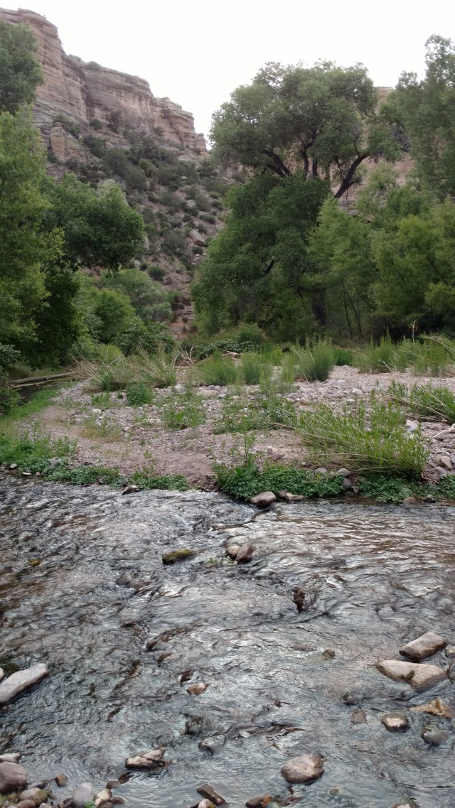
I stepped timidly into the ankle deep creek, while Paul cajoled, “It’s not like your feet are going to get any drier”. Thank you Captain Obvious.
 And so began the day of full unabashed “soakers”, our feet were going to be pruned before the end of the day. Of course the moment I stepped into the water, which was somewhat tepid, I had to pee. Hadn’t I already done that before we donned our packs?
Before we set off, we had read numerous journal accounts of the people journeying through Aravaipa Canyon. We watched YouTube videos and scowered the Aravaipa Canyon Nature Conservancy’s Website, for what to expect, and especially things (critters) to look for and/or be aware of. As we learned there are scorpions, snakes and bitey crawly critters, there would be NO “cowboy camping” this trip. So it was with GREAT SUPRISE that not less that 50 yards in front of us we encountered, within 10 minutes of our hike, a BEAR!
 This BEAR was head down, foraging in the creek and headed our way. He appeared to be a juvenile, so the next thought was, where’s Mama? We stopped dead in our tracks, while he kept slowly working his way toward us. It was obvious that he had no idea we were there, until of course we “greeted” him, saying loudly “Hey Bear!”. He raised his golden brown sun bleached head, tilted his head to the side as if to say, “WTF? What the hell are they doing here?” Another shout of “Hey Bear!”, with raised poles, and he turned tail and charged off in the opposite direction. Three thoughts occurred to us: (1) WTF – a Bear?, (2) Wow, yelling ‘Hey Bear’ really works, and (3) HOLY SHIT, those bears can move REALLY FAST! SO if we thought we hadn’t had enough coffee that morning, this made up for it.
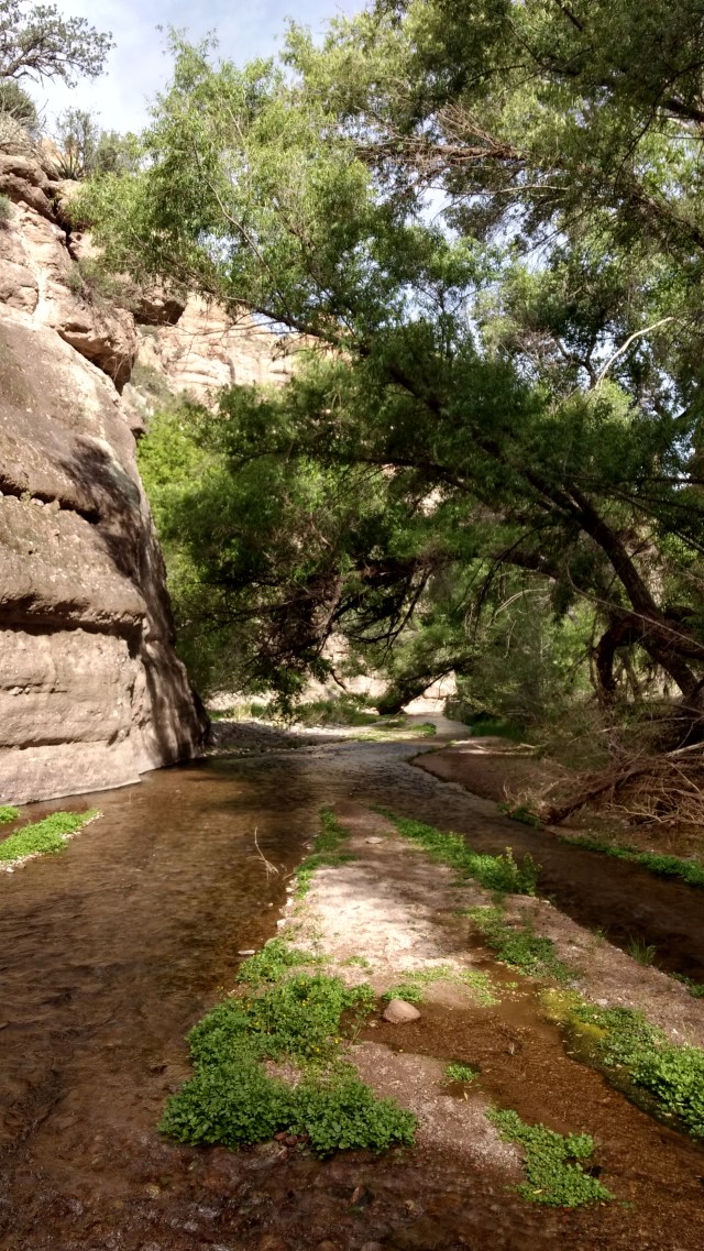
Now walking in Aravaipa Canyon is not like canyoneering in let’s say Zion, or Glen Canyon, it’s more of a very shallow river walk. Mostly ankle deep with some sections just below the knee. The water is just cool enough, this time of year to be refreshing, but definitely not cold. The tread through the water varied between medium cobbles, to coarse colorful gravel and fine sand. And the flow is such that one can walk up or down stream with negligible effort.
While there were some side trails running parallel to the creek, it was often just “easier” to walk in the water, than to bushwhack and/or (for me) worry about being startled by a snake (rattlesnake, or really any snake when you get down to it) on the narrow paths away from the creek, lined with dried golden yellow foxtail grass, soft green pokey tree branches with barbs on them, and/or mini forests of tall green horsetail stalks standing at attention like a box of crayons on the banks of the creek.
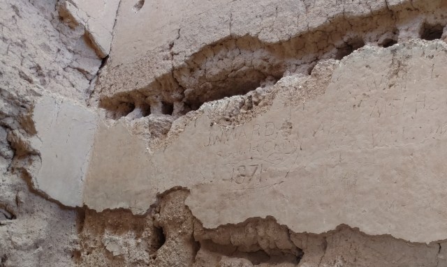
Apparently the “social trail system” was “better” and more defined (kind of like the JMT in Tuolumne Meadows) with deep paths carved into the soil and sand before a devastating flood that wreaked havoc throughout the area July 28th and August 1st of 2006. As a result, the creek bed and vegetation changed significantly, wiping out most of the thick vegetation and previously “established” social trails. Bear in mind, there are no professionally maintained trails or signage throughout the Aravaipa Canyon, with the exception of the West and East Trailheads. Evidence of the flooding and the awesome power of large moving volumes of water in a relatively narrow canyon can be witnessed the length of the canyon.

Aravipa Canyon (2017)
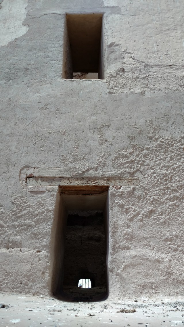
Spectacular erosion and piles of debris stacked high and entertwined with reminants of once full grown Sycamore, Cottonwood and Willow trees were seemingly wedged “expertly” amoungst “sturdier” stands of trees and boulders, and peppered both straightaways and bends in the now softly flowing creek, as if it happened in the recent past as opposed to over 10 years ago.
Our plan was to walk from the East end at Turkey creek to the West end, and then walk back toward the East end and find a suitable campsite for the night. Per the interpretive sign, it had the mileage as 10.75 miles. Piece of cake. Plus a couple miles back to a suitable campsite, and we were golden. Not so fast grasshopper…as 10.75 turned into 13.6 miles by the time we called it, and we hadn’t gotten to, nor found the West end trailhead. As luck would have it, the paper maps of the area (I had printed) had inadvertently gotten destroyed. The first copy fell out of the truck and into Turkey Creek. When I saw a piece of paper in the creek with the GET (Grand Enchantment Trail) logo in the corner, I thought one of the GET hikers had dropped it on their way through. Nope, it was me. It slipped out of the truck as I got out to help Paul level our camper. When I retrieved it, it was a pretty tie-dye design, but otherwise useless. The second map I gave to Paul, who tried to give back to me to carry, but when I pointed what happened to the first map, he acquiesced and stored it in his shirt pocket.
When we stopped for our lunch break at the “half-way” mark at noon in which we had done 7.5 miles (according to Paul’s mileage app on his phone which has been tested for accuracy numerous times) it was time to check the map and count the side canyons we had passed to see where we were in relation to the West end trailhead. But alas, no map to check now, as Paul had rinsed out his sweaty shirt in the creek without having removed the map from his pocket. His once “white” pocket was now dripping with color. Aargh! ‘That’s okay’, we thought. It should only be a little over 3 miles away right? Ha Ha, surely you jest! The map on my phone from our Delormne InReach SE would have been more helpful if we (I) had memorized the number of canyons, their names and what the creek “bend” looked like just before the foot trail that leads to the West end Trailhead…but then I wouldn’t need a map then, would I? SO we walked the 3.25 miles, and found no outlet to the trailhead. I remembered something about there being a BLM boundary marker 1.4 miles out from the West end trailhead, and thought that when and if we came across it, it would give us a better idea of how much further we needed to go. But in keeping with our mis-adventures, we couldn’t find (more likely didn’t see) the BLM boundary marker at what would have been 1.4 miles more to go. We noticed three wooden fence posts in the creek (connected to nothing), but thought, ‘that couldn’t be it, right?’ When we had clocked over 12 miles, and were startled by an enormous rattler cleverly disguised in the horsetail grass at the north edge of the creek I was wandering toward, I (we) then decided that I (we) had had enough. It was either we somehow missed our turn, or maybe we didn’t go far enough. In any event we were toast. So we wandered back eastward looking for a suitable place to camp.
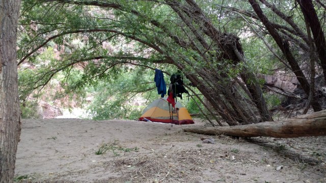
Eventually we found a sandy bench above the creek sheltered by cottonwood trees. When Paul checked the mileage on his phone app, it appears that we were exactly 2 MILES from where we had turned around, and our fastest pace was 68mph (which we attributed to the snake).
After setting up, we purposely soaked our tired feet in the creek as we washed the accumulated sand and gravel out of our socks and shoes. Tiny minnows tickled my toes as they nibbled on the edges on my callused feet. I hear some women pay good money to do that to their feet during a pedicure. As we finished dinner and crawled into our tent, the wind picked up, gusting through the narrow canyon causing ripples on the surface of the softly flowing creek. Soon however, we were fast asleep to the sound of creaking branches and rustling leaves overhead.

 The bartender asked if we wanted any food…we pointed to our glasses, and he nodded in understanding. (Watching the food pass by, we decided that we will definitely hit this place again on the return from our hike). Next stop was the IGA (local grocery store), for our trail chips (no salt and vinegar or chilli cheese Fritos, so we had to try something new). Once back at our campsite we charged our electronics and did the final check of email, as tomorrow will find us with little if any service once we start.


![ChilkootPass_GoldenStairs2[1]](https://2moremiles.com/wp-content/uploads/2017/07/chilkootpass_goldenstairs21.jpg?w=640)


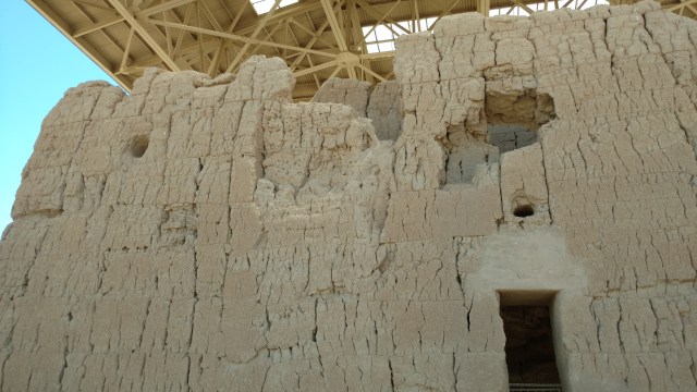

 A dust cloud proceeded the entourage of 4wd vehicles that poured into the creek and our serene abode. Looks like all the permits will be used today! 7 vehicles and 13 people later, the East end 20 were sloshing through the canyon. Luckily we were going the opposite direction. Today was to be an easy day. We were in search of what was to be an intact early Indian cliff dwelling. Off we trod over a wonderfully compact BLM dirt road. One creek crossing, then two, three, four, five (dry does this count?), six, and seven but no corral or sign.


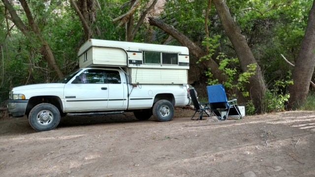 Upon returning to our camper, it was time to pack up and head out. Our goal on the way out was to check out the “resupply” point at the Klondyke Post Office (which is for sale?). And after that to find the “turn” on the Grand Enchantment trail “out of Klondyke”.


