We wanted to avoid going through Phoenix on our way back to California and take the “roads less traveled”, so on our way back to California we of course missed our turn (or rather, took a turn too soon) and ended up taking an even more circuitous route through what we learned (via Google) was certainly the historic “Wild West”. It also weaved through “native lands” (that was pretty much stolen) of some of the oldest peoples of the southwest dating back thousands of years. As history’s hindsight is generally 20-20, these peoples were ironically thought of as “savages”, during the westward expansion of “civilization” and of the United States’ Western territories. When in fact many were fierce warriors protecting their lands. From what we later learned, at the Casa Grande Ruins, they had a sophisticated society, rich in culture, with innovative farmers who created a widespread and amazing irrigation system, that survives today.
Fun Facts: Arizona is home to two of the largest Indian Reservations (or rather sovereign Nations…under which the United States claims Plenary power), the Navajo and the Tohono O’odham. Arizona has the second highest population of Native Americans in the country.
When we left Safford, we drove through small non-descript, often hard-scrabble towns that obviously held some significance in their “hey-day”. Places like: Thatcher (pop. 4,800) founded in 1881 by Mormon settlers and the childhood home of Jess Mortensen, former world record holder of the Decathlon in 1931. He is well known in the annals of USC’s athletic history as an athlete and coach. Pima (pop. 2500) founded in 1879 also by Mormon settlers, originally called “Smithville”. In 1882 Jesse N. Smith predicted a Mormon Temple would be built in Pima, or was it Thatcher (two separate accounts)? Anyhoo, in 2010, The Gila Valley Arizona Temple was built and dedicated ironically between the two towns! Fort Thomas (pop. 374), home of Melvin Jones, founder of Lion’s Club International. It was originally one of the “earliest” military posts in the west (Camp Goodwin), and considered the “worst fort in the Army” due to its persistent problem with malaria. It’s low population makes sense now. Globe (pop. 7500) established in 1875 and whose downtown is on the National Register of Historic Places, with a “wild and wooly” history of Indian conflicts,old west outlaws, stagecoach robberies, gun fights and ruthless murders, as well as the discovery of and mining of silver, and more recently cooper. Florence (pop. 10,000) founded in 1866, is the Pinal County seat, and rich in history, with its “old town” registered as a “National Historic District”. During WWII, Florence was home to “Camp Florence”, the largest POW camp in the United States that housed over 13,000 POWs namely from the North African Campaign. As we worked our way back to the I-10, and about the time we were considering looking for a campsite or campground, we spied a Walmart Superstore that happened to be in Coolidge and on the corner of the one square mile set aside for the Casa Grande Ruins National Monument. We considered just setting up in the parking lot of Walmart, but then thought a shower would be nice, so we searched for a nearby campground and/or KOA. We found a KOA not far from our location, which sent us to the I-8 (again) and to the Picacho KOA (of which was located next to the I-8…and a railroad!). We decided to go to church the next morning in the nearby sleepy town of Eloy, with a “shuttered” Main Street, and an exuberant priest, whose homily was as entertaining as it was insightful. This was followed by breakfast burritos, sponsored by the parish’s Knight’s of Columbus. From there we headed to the Casa Grande Ruins National Monument. While we were originally not too excited, and in fact considered just getting on the road toward home, we decided that we should not pass up a ready opportunity to sample our Nation’s National Monuments. At least this one we wouldn’t have to hike to. Turns out we were pleasantly surprised and completely awed by the monument.
In 1892 President Benjamin Harrison designated this one square mile as a prehistoric and cultural reserve. It was the first time that open land such as this had been put aside for protection and preservation. Go figure! On August 3, 1918 it was later reclassified as a National Monument, now the third such designation in our National Parks history (even though it ACTUALLY was the FIRST).

The external “roof” was erected by the CCC to protect the remaining prehistoric structure
Although this structure was actively used by the ancient Sonoran desert people in the 1300’s (or possibly sooner), it was seemingly suddenly abandoned around 1450 and not “discovered” until 1694 by Padre Eusebio Franco Kino, who gave it its name, “Casa Grande”. It still is considered one of the largest prehistoric structures ever built in North America, and to date we still haven’t figured out its purpose. We have however figured that there are three specifically placed “holes”, based on the structure’s orientation, that are in solar alignment with the Spring and Fall equinoxes (two on the East wall) and the setting sun of the Summer solstice (west wall), which may have “aided in sustaining life” (aka. farming).

In the visitor’s center, built by the CCC (Civilian Conservation Corps) in the 1930’s we perused the well done interpretive displays, and watched a short movie chronicling the “known” history of the Casa Grande Ruins.

Seeing that it was early morning and not too hot, we wandered through the site’s ruins.
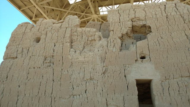
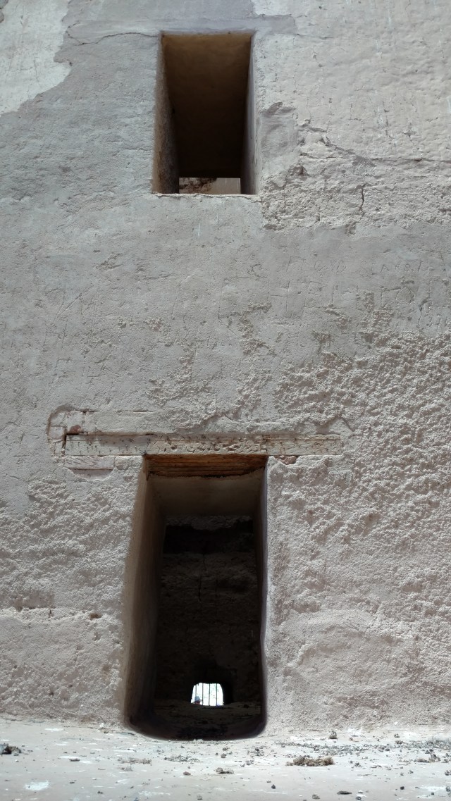
We marveled at the engineering feats of the ancient Sonoran desert people with regard to the structure(s) they built. This particular structure was originally 4 stories with wooden plank floors whose walls are 3.7 ft thick and made of “concrete” adobe. Additionally the compound has several other structures/walls in various states of decay, and once was fed by an intricate and wide-reaching irrigation system (which tapped the Gila River), that based on further studies enabled them to establish a thriving farming community. Apparently they hand dug miles of irrigation canals often 9ft wide and 6ft deep, perfectly graded to allow water to flow evenly from the Gila River. Some of the irrigation ditches and canals are still in use today!
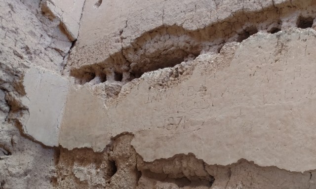
“J. W. Ward 1871 Sgt. 1st Calvary

D. Henness 8-13-1886
We also marveled at the time, the not-so-honored “tradition” of graffiti carved into the remains of Casa Grande. Having a stagecoach route run within yards of the structure didn’t help either. I would hate to be related to these guys who so prominently and permanently etched their names into “history” for an “I was here” moment. Further research (because I’m a nerd) revealed a paper published by Department of Interior (National Park Service), complied by A. Berle Clemensen titled “Casa Grande Ruins National Monument, Arizona: A Centennial History of the First Prehistoric Reserve 1892-1992“, chronicling the “evolution”of the management of the Casa Grande Ruins. I found this paper (156 pages…yes I read it in its entirety) absolutely fascinating and completely enlightening on how the preservation, study and interpretation of property, artifacts, structures and cultural icons of the Casa Grande Ruins evolved under the purview of the Department of Interior, more specifically our National Parks.
We left Casa Grande and ultimately Arizona with a much greater respect and appreciation of our Native Americans, early pioneers and this beautiful and highly interesting state of the Union, that is Arizona.

It is soooooooo FUN to read about your ARIZONA Adventures because I lived there for 40 years!!!!!!! Most of the time was in Mesa where I taught school. I have been to all the places you went except the east end of Arivipa Canyon. We just did an in and out from the west. I do enjoy your ADVENTURES!!!!!
Thank you. Our only previous foray into Arizona was the Grand Canyon. We definitely plan to explore AZ more
Pingback: Casa Grande Ruins – AZ Wonders