
After leaving Pueblo Bonito, we get back into our truck and head to the trail head at the end of the “road”. From here, we have three objectives. (1) Find as many petroglyphs as we can on the Petroglyph Trail. (2) Continue past the Petroglyph Trail to the Pictograph of what is believed to have chronicled a Supernova that occurred sometime around 1054 CE. (3) Continue from the Pictograph to Peñasco Blanco. Round trip, this should be about 8 miles. At the Visitor Center you can purchase a “backcountry” trail guide for $2. We regret not having done so. All “backcountry” trails in Chaco Canyon require a permit, which is free, as this park is “Day Use” only. They want to know who has been in the “backcountry” most likely for two reasons:(1) To make sure you’ve made it back to your vehicle and are not lost and wandering in the “desert”…with no water. Or have been attacked/eaten by the area’s resident mountain lion. (2) They will know who to question if sites have been damaged/disturbed, or pilfered. We complete the triplicate permit, dropping one in the box, one to the car and the other we carry with us. The trail is wide, flat, and is unpaved. From here, if you have a bicycle (mountain), you can ride to the foot of Kin Kletso, which is another structural complex, much “newer” than Pueblo Bonito.

Obviously, because of its “popularity”, additional “neighborhoods” needed to be built. In fact this canyon has over 2000 “neighborhoods” of varying size and decay, most have not been excavated.

We briefly examine this structure, if only to compare construction styles.

From here, we then continue down the now narrow dirt trail that runs at the foot of the canyon’s south-facing cliff walls. We look in earnest for ancient “graffitti”. It is said that only certain persons within each clan/tribe were “allowed” or it was “acceptable” to create the petroglyphs we are about to see, as they are often of “sacred” significance.

Not far into the trail we spy our first petrogylphs. We do our best to “interpret” what we see.


We should have bought the trail guide! We move along the 1 mile section, making a point to look up, and putting to use the binoculars we have borrowed from my father.


Some petroglyphs are “easy” to spy, while others require a “Where’s Waldo” approach, looking for patterns of placement and/or markings not occurring in nature. Much has faded/eroded, sluffed off and/or become damaged from cliff failures overtime. Toward the “end” of the trail we see evidence of “current” markings upon/in the cliff walls along with the ancient markings.


At first we are disgusted, but then under further examination we realize that these marking are ironically from the early 1900’s and the US Geological survey team leaving their, “I was here”, markings.

One even left a “note”, for a colleague. We wonder aloud, why/how this particular 1 mile stretch contained so many markings by the Chacoan people. Again, we lament the fact we do not have a guide…in case it holds some kind of “answer”. Surely there are more places with even more prolific etchings.

We continue from the end of the row of petroglyphs toward a pictograph (painted picture) on the north facing canyon wall, of what is understood to be a recording of a Supernova event, that would have been seen for days by the Chacoan people. The trail is narrow and sandy in parts, but not as well traveled as the trail along the petrogylphs.

We are glad that the skies are overcast and the air is much cooler than “normal”, as it would be foolish to walk this route at mid-day, as we do now. The trail wanders, for us, unnecessarily, as there is evidence of re-routing, most likely due to “over-use” and to rehabilitate vegetation.

We drop down into a “dry” gulch still muddy in parts from last evening/morning rain, and follow the trail as it climbs out and heads to the foot of the cliff walls. For some reason we were expecting a much larger pictograph. In fact, without the wooden sign directly underneath it, one could easily miss it, especially if one was not “looking” for it.

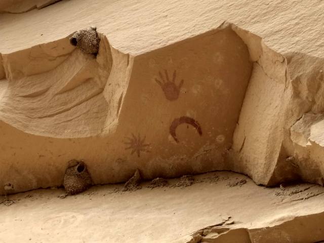
Much erosion must have taken place, for unless the “artist” stood on a ladder, such placement would have been prohibative.
From here we continue a tenuous trail to Peñasco Blanco.

Pingback: Chaco Canyon | 2MoreMiles…