
July 23: Day 35 (1994.5 – 2000.6 + 3.3 of Mack’s Inn Cut-off) 15.4 miles
The intermittent patter of rain continued throughout the night. The youngsters got up early and headed out way before us. We had the option of zeroing at Summit Lake and giving our feet a rest for a day. However, spending the day in our “skinny jeans” tent under rainy/drizzling skies, hiding from hoards of marauding mosquitos, did NOT seem all that restful.

Under grey skies and through water encrusted vegetation we began our trek. We had chosen to take the 32.6 mile Mack’s Inn cut-off, as the thought of carrying 145.7 miles worth of food between resupplies, on the “official” CDT was just too much for us. For some ridiculous reason, we didn’t think about sending a resupply box to West Yellowstone as a means of reducing the food carry weight. Maybe we’ll do that route next year.
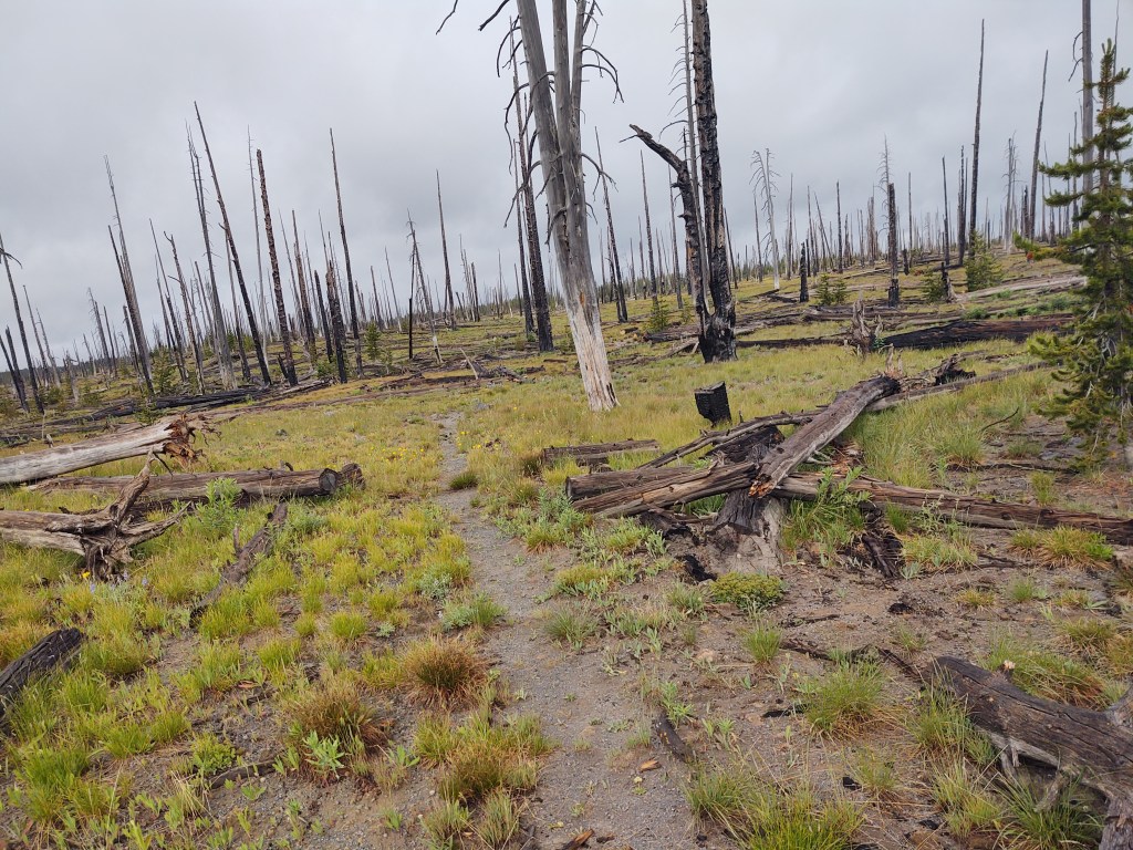
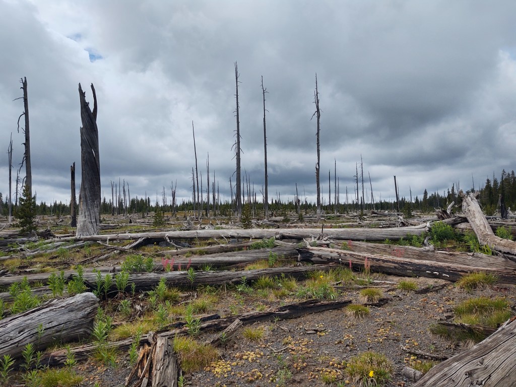
The trail wove through the “outer reaches” of Yellowstone’s boundary. “Islands” of geothermal features smoldered in clusters by the trail. Porous volcanic rocks lined a dormant, bone dry river bed along our path as we continued to the top of the ridgeline where remnants of an obviously replanted and “organized” forest ravaged by fire stood as perimeter sentries. Numerous downed trees lay at our feet. Many we walked around. Others we clambered over.
After breaching a particularly challenging tangle of blow downs (not pictured), requiring the skills of a contortionist (to do it with ease), we met up with a team of obvious Law Enforcement National Park Service Rangers on a trail clearing mission. Additionally “armed” with hand tools for trail work: a cross cut saw (not sure if it was a felling or bucking one), at least one hand chain saw, a single-bit and double-bit ax, a long crowbar and a shovel, they stood like Templar Knights, engaged in a “crusade”, ready for the next “battle”. Each, I assume, carried their “weapon of choice”. They asked about any “foe” we may have faced, and assured us that the path ahead of us was cleared of all lurking trail impediments, within of course, the Yellowstone border. Had they arrived 20 minutes earlier, we would have been spared the acrobatics required for the last tangle of blowdowns.
Better late than never. At least our remaining path could be tread without incursion from our wooded “foe”. If, in fact, we followed the correct trail. But then, this is the CDT and if we don’t get “lost” at least once a day, well then, it’s just not the CDT. More on that later in the post.
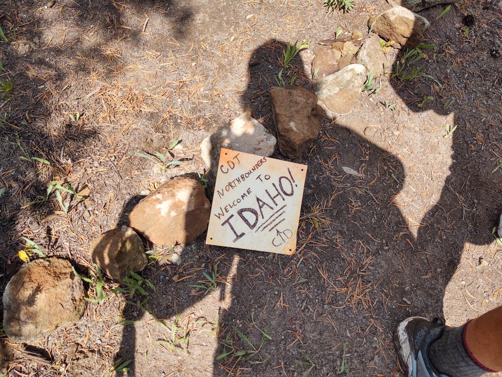
Today was pivotal in that while still in Yellowstone, we would exit Wyoming and enter Idaho. Walking the expanse of one state and into another is exhilarating and you can’t help but feel a unique sense of accomplishment.
What is odd though, is that were it not for the rudimentary hiker “monument”, you’d never know or recognize that you had just breached a border. This led to a lengthy conversation and conjecture as to the how and why states borders were even defined/drawn. We wondered what was significant or unique about that state, and what economic, cultural, ecological and geographic factors played into its delineation.

At the West Yellowstone trail junction, rather than paying particular attention to Guthook, and looking at it from the proper direction, we continued down a well worn path littered with “common” thru-hiker shoe prints. Fat, dumb and happy, we continued until the path became thin and then instantly disappeared, 30 minutes into our “bliss”. Perplexed, we wandered about looking for where we went wrong, and a “short-cut” back to the CDT. Yes, we know better about short-cuts, but for some unexplainable reason we still have yet to be dissuaded from them. My friends surmise it’s because we are “eternal optimists”. I’ll go with that. While it would have been infinitely faster and “effortless” to have just retraced our steps, we once again used Guthook and my Earthmate app to bushwhack our way back to the CDT. Ironically, our bushwhack landed us no more than 20 ft from the West Yellowstone trail junction sign.

The CDT eventually, and quietly exited Yellowstone.

Single track tread led onto now abandoned logging roads, being slowly reclaimed by scattered saplings. It made for easy walking, and based on the sun’s angle in the sky, stands of trees that edged into and beside the “road” created a ribbon of shade to escape the growing heat and humidity. We passed the junction where the CDT turns off the logging road back into the evenly spaced forest. We considered briefly, taking the route, but stuck to the plan to take the Mack’s Inn cut-off. At one point we ducked into a cluster of trees to take a break and escape the heat of the sun. A lone, and obvious CDT thru-hiker (evidenced by his pack and pace) was walking briskly past our shaded enclave. Paul called out to him, “rattling” him just a little bit. He was Damien, from Australia. Paul, recognizing the accent and asked him if he was from New Zealand, just to be funny. He had started from Mexico and was doing his best to finish the CDT in 30 days, by hiking 30 miles each day. We asked him, if that was why he was taking the Mack’s Inn cut-off. “Naw mate, I’m headed to West Yellowstone to resupply”. “Well mate”, Paul replied, “you’re going the wrong way. You obviously missed the turn, and walked over the ‘Mack’s Inn’ spelled out with logs in the road with an arrow.” Quickly Damien (who hadn’t seen enough people to acquire a trail name) pulled out his phone and searched his Guthook app. “Oh well, it’s not the first time this has happened.” Phew! So it isn’t just us that gets lost in this trail. A short and pleasant conversation ensued. We asked him how he plans to get to and enter Canada. He had a route planned, and because he holds an Australian/UK passport, he is able to enter Canada, where his sister who lives there will pick him up. We talked about the trail. Its challenges and “constants” like, getting lost, PUDS, inconsistent signage and the value of Guthook. We shared a few quick stories, but in order to get his 30 miles in for the day (as he was “ready” to be done with hiking) off Damien trotted back from whence he came to his proper turn-off.
Our water stop for the day was Latham Spring 250 ft off the CDT. It had an intricate labyrinth of directions to get to the spring. We studied it carefully, so as not to miss our exit to the spring.
As we walked the once maintained Forest Service and logging roads, we noticed they degraded into a purposely spaced series of serious mounds and corresponding ditches. An obvious, but seemingly costly means of discouraging any type of wheeled motor-driven conveyance. We also wondered if it was also a means of slowing snow-mobiles in the winter months. Maybe, by discouraging motor driven vehicles it also “protected” the forest from man-induced fire or degradation. What we later discovered is that they actually Water Bars. They are placed on abandoned logging roads, when a harvest has been completed to minimize erosion and stream sedimentation in that particular tract.

These particularly deep water bars, like the dozen or so we walked around, are used on roads that are intended to be closed for a significant period of time. I assume that it also preserves the integrity of the road against destructive erosion so that when it comes time to harvest the tract again, the roads can be rehabilitated for significantly less cost and time.
When we got to the “exit” to Latham Spring, we followed the “treasure map” direction up over the berm and down a narrow draw to a deeply recessed cistern with icy cold and clear water. Deep green vegetation and richly colored flowers adorned either side of the spring. With delicious water in tow, we headed back to the trail. As we walked I noticed evidence of prior habitation in the form of broken shards of cups and plates (pre WWII) and rotting tin cans. This makes sense so close to a reliable water source.
We had every intention, prior to collecting our water, of walking additional miles.


But, when we returned to the CDT path, we couldn’t help but notice how black the skies above us had become, especially over the direction of which we were headed. Seeing as the trail was as flat as it ever was going to get, we decided to make camp at our “leisure” before it became a scramble.
No sooner than we had finished making camp, the wind began to blow ferociously and the temperature suddenly dropped. It was a sure sign that we were about to be rained upon. Into our tent we ducked, pleased at having read the sky and its timing properly.
Gentle drops began against the fly of our tent, steadily increasing their cadence and vigor. A full fledged deluge ensued, as if someone stood above us with a fire hose. Flashes of lightning, followed by ground shaking booms and rumbles of thunder felt like we had just been thrust into a rave party.
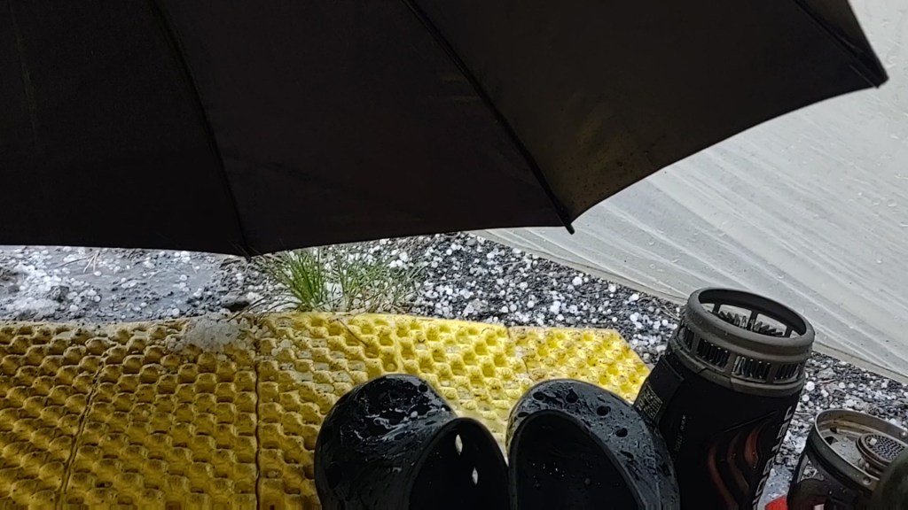
Skittles sized hail pelted our tent, threatening to breach the fly, while others “invaded” the interior having bounced off the ground and under the vestibule doors. This went on for a good 30 minutes.

Our fly showed signs of oversaturation. We were concerned that it was about to “rain” inside as well. Quickly we collected our already unfurled, down sleeping bags and safely tucked them under our rain gear. This was going to be a long night, we concurred. Then, as quickly as it started, it stopped. It was eerily quiet. Not a breath of wind. We waited in silence. Paul gingerly unzipped his vestibule door. “Check it out. Not a cloud above us. Total daylight”, as he eased his way out of the tent.
“Phew don’t think I could have lasted any longer”, I told Paul, heading off to pee. I hadn’t had a chance to pee before the deluge had started and the sound of “running water” wasn’t helpful either. Once “business” was completed, we carefully removed our rainfly, shook it “dry”, and refastened it above the tent body. A slight breeze had resumed, and the circle of blue sky above us began slowly to be swallowed up by the ring of ever darkening clouds. Off in the distance, and much further down the trail, the sky was black. We could see curtains of rain falling and hoped the “youngsters” were warm and dry. Round two, for us, was about to begin.

Paul securely hung our food in a “nearby” tree and we retreated to the confines of our “skinny jean” tent, and watched a downloaded Netflix episode of “Stateless” before the sound of rain against our tent was too loud to decipher the voices.
Eventually sleep overtook us, with no expectations of awaking fully dry.
