
Day 16: 4.9 mi (1585.1 – 1590)
Short miles, but it’s all Paul could muster after leaving from a leisurely morning. It rained last night, so we figured we let everything dry out. The next two afternoons are supposed to be “extreme” thunderstorms, so it would be nice to have all “dry” stuff. The day was uphill ALL the WAY. We took little bites at a time as Paul was still not 100% with regard to energy.

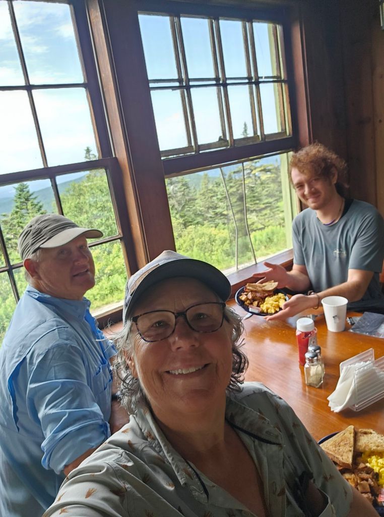
We ran into Giddy-Up again. He’s been slack packing most of the trail he’s spent his life. For the last 4 days, he, too, has been having stomach problems. Something going around? We hope not. We arrived around noon at the Mark Noepel Shelter, and toyed with the idea of maybe going all the way to Greylock, but then that idea was quickly dashed after Paul layed down in one of the bunks and went to sleep. Nope, we’ll stay. Later that afternoon, just as the skies were darkening, two other NOBO hikers arrived. They quickly filtered water and were betting on their trail legs to get them the next 3 miles to Mt. Greylock before the skies opened. We wished them luck. Shortly thereafter, two other hikers arrived, Sweat Potato (he’s a software engineer from Idaho) and Unicorn (who is totally Keto for this hike. Watched him eat a brick of cheese and a 5lbs summer sausage). Both wondered aloud whether the two that had ducked in for water would make it. Neither were confident, when suddenly and right on time as predicted by our weather app, the wind blew fiercely and then the sky spigot was turned on FULL!

We all watched in awe as the deluge came down. The air roared, and the sky blinked. It was an angry storm for sure, and we were glad to be in the shelter. Some time later, another hiker dressed in a thick yellow slicker that covered he, and his pack showed up. Sasquatch was his moniker. He was a SOBO and had gotten caught on his way down from Mt. Greylock. He joyfully emerged from his slicker, “That was NUTS!”, he exclaimed. We all looked at each other in agreement. Sasquatch was full of, what I suspected was nervous energy, having hiked through a deluge of an electrical storm. Can’t say I blame him. Needless to say, he kept us pretty entertained into the evening, especially when he exited the shelter in the driving rain to set up his tarp for his hammock. What?! We reminded him that there was room inside the shelter to set up his hammock, but he declined, saying, “I snore pretty badly.” Alright, no argument there.
Our plan for the morning was to get up early and try and make breakfast at the lodge on Greylock. Sweat Potato was down for that, as well. Ascending Mt. Greylock would find us at the highest point (3,489 ft.) in Massachusetts, where in the 1930’s they built a war memorial to honor those who fought in the “war to end all wars”, WWI. Too bad we didn’t learn from that war.
Day 17: 9.6 mi. (1590 – 1599.6)

Up and early we had a cooler morning than we’ve experienced thus far. It was refreshing and felt “normal”. Granted it would have liked to have eaten something, but Paul was feeling good and ready to go. And that was a relief. We wound our way uphill to Greylock and arrived just in time for breakfast at the Bascome Lodge.
Bascome Lodge is one of the many buildings built by the Civilian Conservation Core (CCC) in the 1930’s.
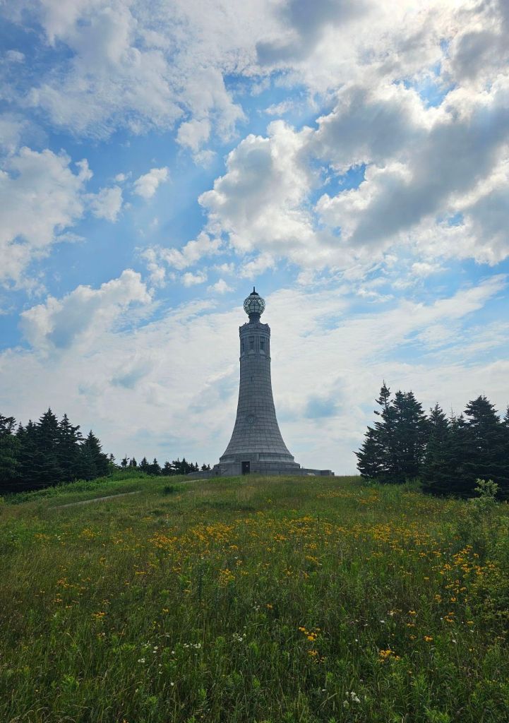
After breakfast, we examined the lighthouse style monument and climbed the spiral staircase to the top for its stunning view.

We didn’t tarry long as we knew another storm was scheduled for the early afternoon. Our job was to get into Williamstown before it broke.
We were so close to making it to the motel dry, but no, soaked to the bone it was. Rocky from the Williamstown Motel picked us up at Hwy 2 and graciously drove us to his motel, where we were able to secure their last room. At least that timing was good. Once we arrived at the motel, we had two problems. 1. We had no dry town clothes, and they didn’t have loaners. 2. Paul’s phone wasn’t working. It was telling him that he was mow missing his SIM card. How does that happen. Likewise, my phone wouldn’t charge due to moisture “detected ” in the charging port. Great. Thankfully, there was a hair dyer in the bathroom, so I got to drying the essentials, our shorts. Our sleep shirts, rain jackets, and Crocs would get us around. Hopefully, the Verizon store in North Adams would be able to help us. First, we had to get there. Rocky pointed us to the free municipal bus, as it would take us to exactly where we needed to go. He said he’d come pick us up if the bus stopped running by the time we were ready to come back.
The bus dropped us exactly where we needed to be. John at the Verizon store treated us well, and soon Paul had a working phone, and as bonus, we had a lower bill. Trail magic?

Day 18: 11.5 mi. (1599.2 – 1619.7)
It poured ALL night long. We are so glad we made the decision to motel it last night. I’m pretty sure we would have been wetted out and fairly miserable. It was a bit of a late start, as one can’t pass up a continental breakfast or a ride back to trail. Not to mention, I awoke to looking like a Unicorn. Apparently, a mosquito got me smack dab in the upper forehead. This is gonna make pulling down my hat brim a little uncomfortable.


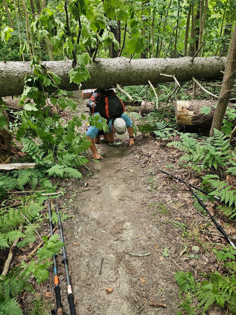
As we started the trail, a beautiful stream sauntered beside us as we climbed. It appeared that Massachusetts was going to usher us out as we came in. A bubling stream and a rolling climb. Today, we would finish our second state on the Appalachian Trail, and enter Vermont.

Vermont welcomed us gently and then turned on us. ‘Oh, you thought Connecticut and Massachusetts were bad with roots, rocks, and climbs? We have those too, but we’ve added MUD to the mix.’ Squishy black, shoe swallowing, mud. Nice.
We now understand why they call it Vermud. The mud has a way of hiding hazards. The edge of my left foot caught one and caused some serious discomfort. So, our planned 14-mile day, reduced to 11.

This left us by ourselves in a relatively new shelter ( Seth Warner). Darn. Tomorrow, we duck into Bennington for a quick resupply.
Day 19: 8.9 mi. (1610.7 – 1619.6)
So we had the shelter to ourselves for the night, which made for a casual morning. We knew it would be a short mileage day, as we have to duck into Bennington for a 4 day resupply. We have yet to figure out our eating verses mileage formula for this trail. I do know that we are getting hungrier. The problem is that healthy food carries are so much heavier.
It appears that it won’t be the treacherous parts of the trail that will do me in, but the easy, cruisey parts. Once again, on the “pleasant” side of Harmon Hill, I violently rolled my right ankle yet again. The soft dirt broke my fall, and the ankle roll nearly broke my spirit, as Paul exclaimed, “It’s perfectly flat. How does that happen?” I have no answer, only that if it weren’t for the fact that this ankle is so loose as it is, I’d be done.
Back on my feet, I didn’t even bother to dust myself off. What’s the point. We snacked at Harmon Hill and called Maria to shuttle us to the Bennington Walmart. She’d meet us at the Hwy in a black Jeep. Our final descent to Hwy 9 was rigorous in the fact that it appears that short people, or people with impaired knees, do NOT build steps or are at least not consulted. Oh, to have trail legs. We made it to our ride with several minutes to spare with our proposed estimated arrival.
A quick resupply at Walmart, and Maria picked us up again and drove us back to trail. In speaking with her, we discovered that her daughter is currently hiking the PCT. In fact, her daughter rode with us AND stayed at Camp Lockett (CLEEF). Paul quickly pulled up her picture from our campfire program. Maria smiled in affirmation, “That’s her.” Who’d a thunk that the mother of YouTube sensation, “The Hiking Dancer” would be our shuttle driver on the Appalachian Trail. The world continues to shrink.

Four days of food, and up the hill (1357′) we walked for another 1.6 miles and to round out the day.
Day 20: 12.8 mi. (16+9.6 – 1632.4)
It was not a good day. AT ALL! It wasn’t that muddy, but my foot was still sore which made for a bad attitude, which became amplified when Paul thought it a “good idea” to help me be “more efficient ” in using my trekking poles. He tried to be “helpful” like that 10 years ago on the PCT, with similar results. In any event, we were able to stomp out nearly 13 miles, before we called it at the Kid Gore Shelter.
Day 21: 14.4 mi. (1632.4 – 1650.9) via blue route
Good thing we arrived at the Kid Gore Shelter when we did and got a campsite because this place was packed! The kids were up till late, yapping loudly and up early again for the sunrise that presents itself at this particular shelter. With the exception of the first night on trail, we both have yet to sleep well, or at least soundly and awake rested. We are, however, having wild dreams. What’s weird is that the content is completely unrelated to hiking or anyone/thing we know. Completely bizarre how our brains can generate things we have no conscious experience with. On the other hand, our feet are feeling better each morning, which is encouraging.


But, what a difference a day and a clean pair of underwear makes. It’s town day, and with a much better attitude, we hit the trail. Our first stop will be the purported best spring water on trail by the Story Spring Shelter. The reports on FarOut are NOT wrong. The water is glorious. While there snacking and drinking, we watch as “Mowgli” pulls out a sticker (ours) and places it on his phone cover. Paul asks him, “Hey. Where’d you get that sticker?” “Not sure, but it’s cool, “Mowgli replies. After some discussion, we narrow it down to the cabin at Goose Pond, where we left a litter of stickers. Paul tells him and the others resting at the shelter about our business, and we pass out a few more stickers, and glean information from them as to what we have to look forward to when we flip.
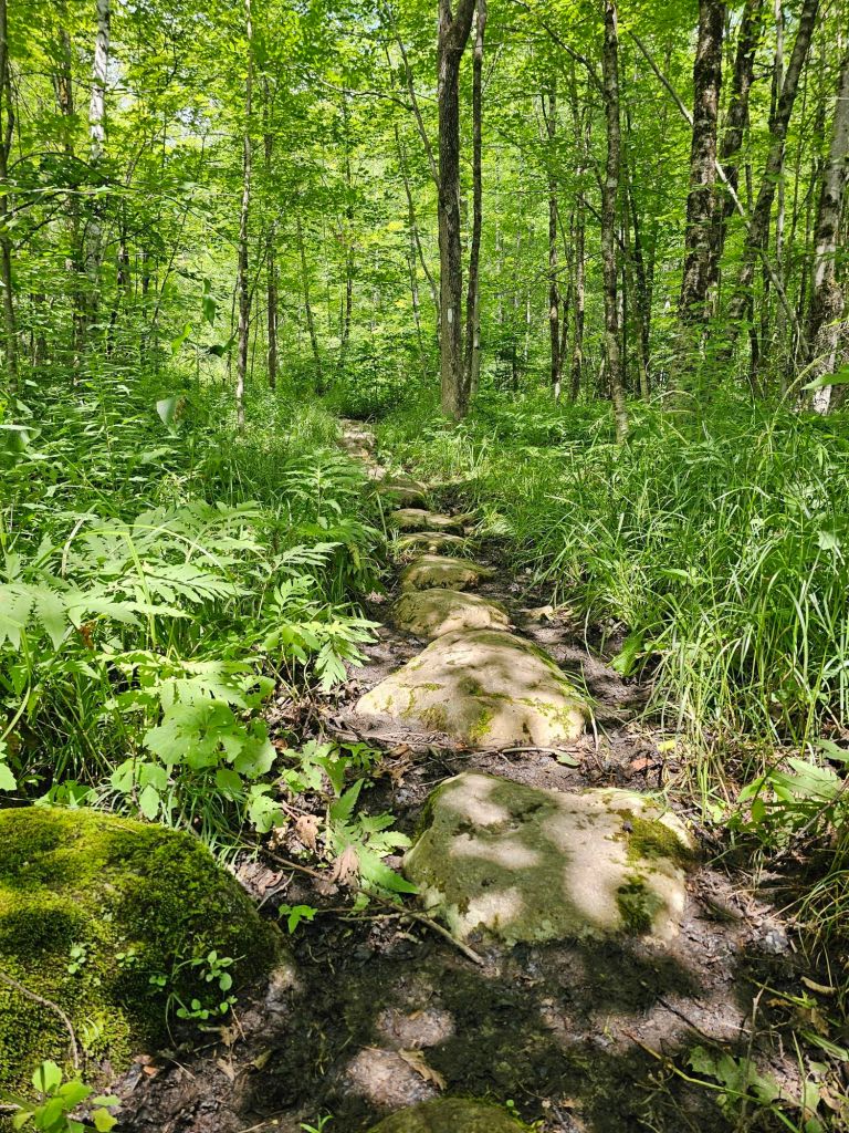
Because my foot was still a bit tender, we opted to take an alternate that would keep us from a big climb and descent. This would shave off 4 miles, but possibly save us from a zero or more once we made it to Manchester. Even so, we still stomped out just under 15 miles, our best day so far. We can’t seem to trek much over 2 mph. Our average is 1.5 – 2, so far. Without trail legs and goat feet, anything averaging 2mph will be impossible with the tread of this trail. With tired feet, and just after a flowing stream, we found a stealth site to camp. There is no way we were going to make that last 1.4 mi to the shelter.
Day 22: 7.2 mi (1650.9 – 1658.1)


TOWN Day!! Best night’s sleep so far. Stealth camping agrees with us. Motivated by town, we moved rather “quickly,” or rather the trail “allowed” us to… until it didn’t. Needless to say, the last 3 miles were not as easy as the first 4. When we got to the highway, we crossed the road into the trailside parking lot and we’re greeted with amazing trail magic. By the time we had downed a beer and some treats, a car arrived, dropping off another thru-hiker. He announced, “I’m headed back to town. Does anyone need a ride?” Yup!
Michael zipped us into town and gave a tour of the town of Manchester, which included the Orvis corporate headquarters, outlet, and fishing school. I so wanted to get out and take a look, but I knew better. Eventually, he dropped us at the Hampton Inn, where we used our points and got a room. From there, we hooked it to the outfitters, for some food, a new filter cartridge, and a pair of shorts that hopefully will dry faster on/for me. Next was Shaws (like Vons or Albertsons) for the remainder of our resupply, fresh food/dinner, and a couple of beers.

One thing Manchester does not have, are any phone stores or repair places. Since leaving Williamstown, I have not been able to charge my phone. It keeps telling me that the charging port is wet…but it’s not, anymore. Our “waterproof ” phone carriers on our pack are no longer waterproof. It appears that we’ve worn them out or that it’s too darn wet all the time for them to even keep up. I was finally able to call a Verizon tech and just like taking your car to a mechanic to tell them about a noise, and the noise goes away. Somehow, it began to charge, but intermittently. The tech was able to walk me through a way to reset my phone (without losing anything) and allow it to charge via the charging port. When we get into Rutland, I’ll go to the Verizon store there and get a wireless fast charger so I won’t have to use the charging port to charge my phone. Duct tape and a zip lock bag should keep it safe till then.
Because we could, we hit the jacuzzi for a good soak before bed. With laundry done and bags packed, we watched a movie as it poured buckets of rain outside our window.
Life is good!

i am loving your blog and the pics. You two are so adventurous. So cool. Stay dry😉 .
Unfortunately, dry is not really a thing here on this trail…😆